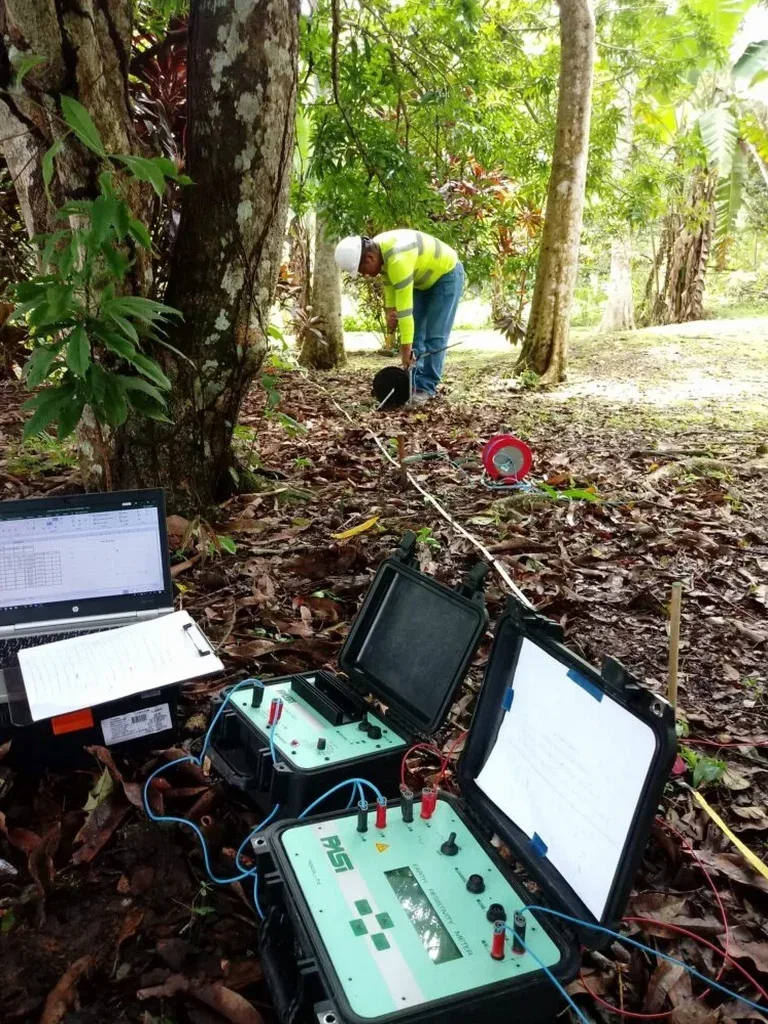
Spokane’s geology doesn’t read like a textbook—it reads like a flood. The Missoula outbursts scoured the valley, dumping chaotic sequences of gravel, silt, and clay over Columbia River Basalt. When a driller hits refusal at 12 feet on the South Hill and 80 feet in Hillyard, you need more than a guess. Electrical resistivity testing cuts through that ambiguity. A Vertical Electrical Sounding (VES) array sends current into the ground and measures apparent resistivity at expanding depths, distinguishing saturated gravel from dry basalt without a single borehole. For projects near the Spokane River or the Rathdrum Prairie aquifer, where groundwater protection is non-negotiable, we integrate VES data with subsurface characterization to map flow paths before excavation. Our field crew runs Schlumberger and dipole-dipole arrays on commercial lots and transmission corridors alike, delivering 1D and 2D profiles that tie directly to local IBC site classification requirements. When borehole spacing gets thin, resistivity fills the gaps with physics, not assumptions.
Resistivity doesn’t lie about saturation. When the VES curve drops, you’ve hit water—and in Spokane that’s often perched on basalt.
How we work
Local ground factors
We surveyed a warehouse pad in Spokane Valley where the geotech report showed basalt at 15 feet across three borings. The grading contractor hit a buried channel of saturated silt at 22 feet—right between boreholes—and the subgrade turned to soup after the first rain. A VES line across the pad would have flagged that low-resistivity zone before a single scraper moved. That’s the blind spot with borehole-only investigations in glacial outburst terrain: the ground changes faster than your grid spacing. Missed paleochannels, undetected groundwater mounds on basalt ledges, or fill pockets with high clay content all produce resistivity signatures that demand interpretation, not dismissal. We’ve also seen resistivity misread when surface infrastructure—buried utilities, chain-link fences, reinforced slabs—isn’t accounted for in the electrode layout. Our protocol includes a utility clearance walk and a site sketch marking every conductive feature before the first current injection. In Spokane, where half the industrial lots sit on historical fill from rail yard and mill operations, skipping that step means mapping a pipe trench as a sand lens.
Applicable standards
ASTM D6431-18: Standard Guide for Using the Direct Current Resistivity Method, IBC 2021 Section 1803: Geotechnical Investigations, ASCE 7-22 Chapter 20: Site Classification Procedure, NIOSH 8128: Electrical Safety for Geophysical Surveys
Associated technical services
1D Vertical Electrical Sounding (VES)
Schlumberger array with expanding electrode spacing. One sounding per location, resolving resistivity versus depth to map basalt, groundwater tables, and clay layers. Ideal for bridge foundations, tower pads, and wellhead protection zones where vertical stratigraphy controls design. Delivered as a layer model with interpreted lithology cross-referenced to regional borehole logs.
2D Electrical Resistivity Tomography (ERT)
Multi-electrode profile with dipole-dipole or Wenner-Schlumberger arrays. Resolves lateral and vertical resistivity variations along a transect. Applied on pipeline alignments, landslide investigations, and brownfield sites where contaminant plumes or buried debris need delineation. Output is a georeferenced resistivity cross-section with RMS error and iteration history.
Typical parameters
Quick answers
How deep can a VES survey see in Spokane’s geology?
With a 400-meter maximum current electrode spread (AB/2 = 200 m), we typically achieve an investigation depth of 80 to 120 meters in Spokane’s alluvial and basalt terrain. Depth of penetration depends on the resistivity contrast between layers and the transmitter power available. In areas with conductive clay or saturated silt near the surface, current attenuates faster and the effective depth may reduce to 60–70 meters. For deeper targets—such as mapping the base of the basalt sequence—we discuss whether a wider spread or a magnetotelluric complement is warranted.
What is the cost range for an electrical resistivity survey in Spokane?
Electrical resistivity surveys in the Spokane area generally range from US$630 to US$980 for a single VES sounding with interpretation. A 2D ERT profile of 200–400 meters length, including data processing and a report, falls within a higher bracket due to field time and electrode setup. Final cost depends on site access, line length, electrode count, and whether topographic survey or utility clearance is required. We provide a fixed-price quote after reviewing the site plan and project objectives.
Which array type works best for detecting groundwater in basalt?
Schlumberger arrays give the cleanest vertical resolution for detecting a saturated zone within or above basalt, because the expanding electrode geometry emphasizes resistivity changes with depth. Dipole-dipole arrays are better for lateral mapping—useful when tracking a perched water table across a slope. In Spokane, where groundwater often sits at the sediment-basalt contact, we frequently combine a Schlumberger sounding with a short dipole-dipole profile to confirm continuity.
Can resistivity testing replace boreholes for site classification?
No, resistivity testing does not replace boreholes for IBC site classification. It complements them. Resistivity provides continuous subsurface information between boreholes and can reduce the number of borings needed, but a direct measurement of soil type, SPT N-values, or shear-wave velocity from a borehole or CPT is still required for Site Class assignment per ASCE 7-22 Chapter 20. We often pair VES with MASW or downhole seismic to build a defensible ground model that satisfies both the geotechnical and geophysical data requirements of the building official. More info.